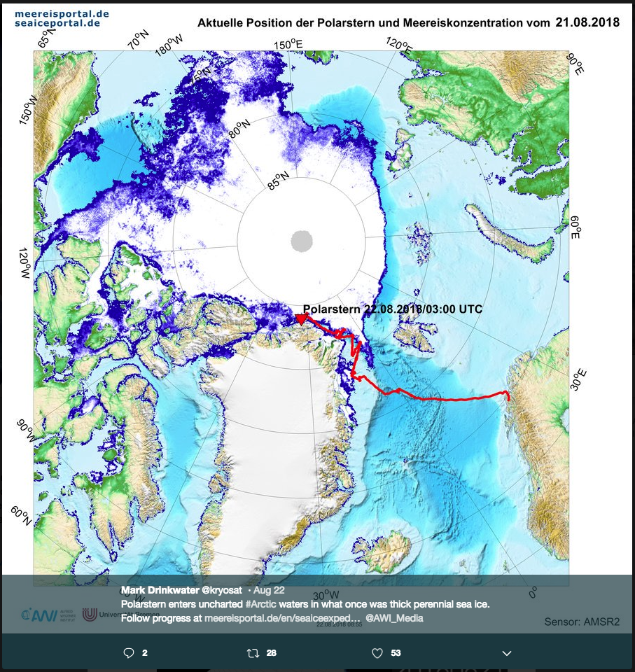
Polarstern enters uncharted Arctic waters in what once was thick perennial sea ice
Mark Drinkwater’s (@kryosat) tweet on August 22, 2018
https://twitter.com/kryosat/status/1032172161635639296
Polarstern enters uncharted #Arctic waters in what once was thick perennial sea ice. Follow progress at https://t.co/BXplVLWjDj @AWI_Media pic.twitter.com/Kueb5QxDTr
— Mark Drinkwater (@kryosat) August 22, 2018
[36]:
from IPython.display import Image
Image(filename='resources/kryosat_tweet.png')
[36]:

Objective
This first notebook will demonstrate how to:
- Get and cleansing the Polarstern AIS data
- Use the Polarstern position at 2018-08-22 03:00 to discover Sentinel-1 data
- Stage-in the discovered Sentinel-1 data
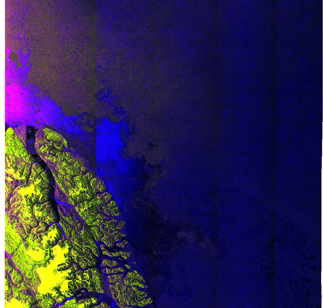
- Plot a quicklook of the staged-in Sentinel-1 product
Workflow
Python modules
First, a few Python modules:
[3]:
import matplotlib
import matplotlib.pyplot as plt
%matplotlib inline

import cioppy
import numpy as np

from shapely.wkt import loads
import shapely
from shapely.geometry import Point
from shapely.geometry import LineString

import ipywidgets as widgets
from ipywidgets import interact, interactive, fixed, interact_manual
from ipywidgets import HTML

from geopandas import GeoDataFrame
import pandas as pd

import pytz
from datetime import datetime

from ipyleaflet import *
import subprocess
Download the Polastern AIS data
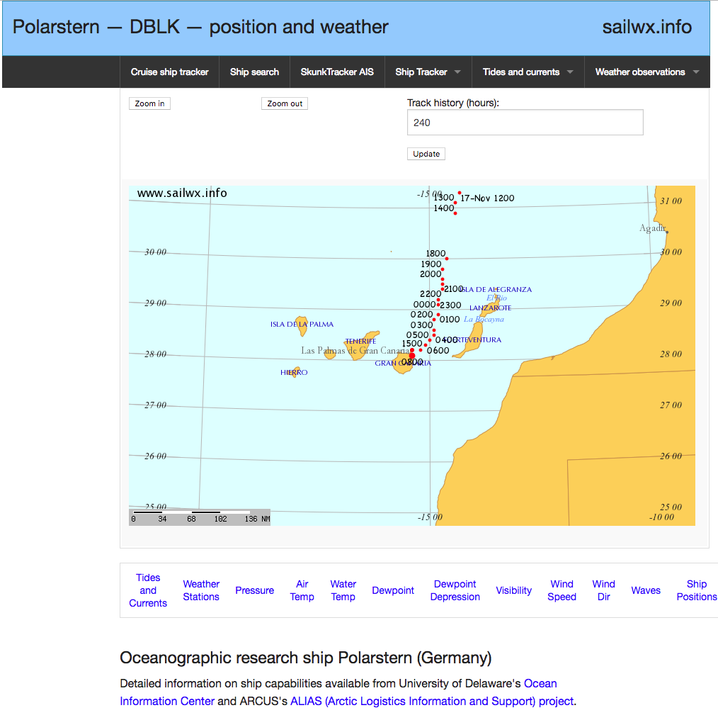
Open the Polarstern AIS sailwx webpage https://www.sailwx.info/shiptrack/shipposition.phtml?call=DBLK
[4]:
Image(filename='resources/polarstern_sailwx.png')
[4]:

Download the full AOIS Polarstern data at the link Dump ship’s entire track history:
[5]:
Image('resources/polarstern_dump_info.png')
[5]:

Upload the file shipdump.html
Polarstern AIS data cleansing
[37]:
ais_positions = 'shipdump_DBLK.html'
Open the Polarstern entire track history and store all lines in a list
[38]:
fin = open( ais_positions, "r" )
data_list = fin.readlines()
fin.close()
Remove the HTML tags (first four lines and last three lines)
[39]:
del data_list[0:4]
del data_list[-3:]
[40]:
data_list[0] = data_list[0].rstrip('\n').rstrip(',')
Save the track history as a comma separated values files and then open it as a Pandas dataframe (more info about Pandas and Pandas dataframes)
[41]:
f = open('polarstern.csv', 'w')
f.writelines('\n'.join(data_list))
f.close()
df = pd.read_csv('polarstern.csv')
Show the first AIS positions
[42]:
df.head()
[42]:
| UTC date/time | Unix UTC timestamp | lat | lon | callsign | wind from | knots | gust | barometer | air temp | dew point | water temp | |
|---|---|---|---|---|---|---|---|---|---|---|---|---|
| 0 | 2018-Nov-15 0800 | 1542268800 | 41.4 | -11.3 | DBLK | 80 | 7.7754 | NULL | 1013.8 | 15.2 | 14.6 | 16.1 |
| 1 | 2018-Nov-15 0700 | 1542265200 | 41.7 | -11.2 | DBLK | 150 | 7.7754 | NULL | 1014.2 | 15.2 | 14.5 | 16.1 |
| 2 | 2018-Nov-15 0600 | 1542261600 | 41.9 | -11.2 | DBLK | 110 | 5.83155 | NULL | 1013.4 | 15.1 | 14 | 15.7 |
| 3 | 2018-Nov-15 0500 | 1542258000 | 42.1 | -11.1 | DBLK | 160 | 5.83155 | NULL | 1013.1 | 15.2 | 13.5 | 15.9 |
| 4 | 2018-Nov-15 0400 | 1542254400 | 42.4 | -11.0 | DBLK | 190 | 9.71925 | NULL | 1013.1 | 15.2 | 13.6 | 15.3 |
Convert the ‘Unix UTC timestamp’ to a date/time in ISO 8061 format as a new column
[43]:
df['UTC date/time'] = pd.to_datetime(df['Unix UTC timestamp'].apply(lambda x: datetime.utcfromtimestamp(x).isoformat()+'Z'))
Remove the ‘Unix UTC timestamp’ column, we no longer need it now that we have the ‘UTC date/time’ column
[44]:
df = df.drop(['Unix UTC timestamp'], axis=1)
[45]:
df.head()
[45]:
| UTC date/time | lat | lon | callsign | wind from | knots | gust | barometer | air temp | dew point | water temp | |
|---|---|---|---|---|---|---|---|---|---|---|---|
| 0 | 2018-11-15 08:00:00 | 41.4 | -11.3 | DBLK | 80 | 7.7754 | NULL | 1013.8 | 15.2 | 14.6 | 16.1 |
| 1 | 2018-11-15 07:00:00 | 41.7 | -11.2 | DBLK | 150 | 7.7754 | NULL | 1014.2 | 15.2 | 14.5 | 16.1 |
| 2 | 2018-11-15 06:00:00 | 41.9 | -11.2 | DBLK | 110 | 5.83155 | NULL | 1013.4 | 15.1 | 14 | 15.7 |
| 3 | 2018-11-15 05:00:00 | 42.1 | -11.1 | DBLK | 160 | 5.83155 | NULL | 1013.1 | 15.2 | 13.5 | 15.9 |
| 4 | 2018-11-15 04:00:00 | 42.4 | -11.0 | DBLK | 190 | 9.71925 | NULL | 1013.1 | 15.2 | 13.6 | 15.3 |
Create a geo data frame including the conversion of the lat/lon columns to a geometry
[46]:
geometry = [Point(xy) for xy in zip(df.lon, df.lat)]
df = df.drop(['lon', 'lat'], axis=1)
crs = {'init': 'epsg:4326'}
gdf = GeoDataFrame(df, crs=crs, geometry=geometry)
[47]:
gdf.head()
[47]:
| UTC date/time | callsign | wind from | knots | gust | barometer | air temp | dew point | water temp | geometry | |
|---|---|---|---|---|---|---|---|---|---|---|
| 0 | 2018-11-15 08:00:00 | DBLK | 80 | 7.7754 | NULL | 1013.8 | 15.2 | 14.6 | 16.1 | POINT (-11.3 41.4) |
| 1 | 2018-11-15 07:00:00 | DBLK | 150 | 7.7754 | NULL | 1014.2 | 15.2 | 14.5 | 16.1 | POINT (-11.2 41.7) |
| 2 | 2018-11-15 06:00:00 | DBLK | 110 | 5.83155 | NULL | 1013.4 | 15.1 | 14 | 15.7 | POINT (-11.2 41.9) |
| 3 | 2018-11-15 05:00:00 | DBLK | 160 | 5.83155 | NULL | 1013.1 | 15.2 | 13.5 | 15.9 | POINT (-11.1 42.1) |
| 4 | 2018-11-15 04:00:00 | DBLK | 190 | 9.71925 | NULL | 1013.1 | 15.2 | 13.6 | 15.3 | POINT (-11 42.4) |
Set the index on the UTC date/time column (we can’t use the line index…)
[48]:
gdf = gdf.set_index(gdf['UTC date/time'])
Create a new geo data frame for the August AIS data:
[49]:
august = gdf[(gdf['UTC date/time'] >= '2018-08-01 01:00:00') & (gdf['UTC date/time'] <= '2018-08-31 04:00:00')]
[50]:
august.head()
[50]:
| UTC date/time | callsign | wind from | knots | gust | barometer | air temp | dew point | water temp | geometry | |
|---|---|---|---|---|---|---|---|---|---|---|
| UTC date/time | ||||||||||
| 2018-08-31 04:00:00 | 2018-08-31 04:00:00 | DBLK | 240 | 11.6631 | NULL | 998.2 | -1.79999 | -4.69999 | -0.100012 | POINT (-12 78.8) |
| 2018-08-31 03:00:00 | 2018-08-31 03:00:00 | DBLK | 250 | 11.6631 | NULL | 998.1 | -1.50001 | -4.4 | -0.799994 | POINT (-11.6 78.8) |
| 2018-08-31 02:00:00 | 2018-08-31 02:00:00 | DBLK | 260 | 9.71925 | NULL | 997.8 | -1.4 | -3.50001 | -0.9 | POINT (-11.1 78.8) |
| 2018-08-31 01:00:00 | 2018-08-31 01:00:00 | DBLK | 260 | 11.6631 | NULL | 997.5 | -1.29999 | -3.69999 | -0.500006 | POINT (-10.6 78.8) |
| 2018-08-31 00:00:00 | 2018-08-31 00:00:00 | DBLK | 270 | 13.60695 | NULL | 997 | -1.00001 | -3.50001 | -0.100012 | POINT (-10.1 78.8) |
[51]:
august.plot()
[51]:
<matplotlib.axes._subplots.AxesSubplot at 0x7f7ace6b4f50>

Where was Polastern at 2018-08-22 03:00:00?
The tweet is about the Polarstern position at 2018-08-22 03:00:00:
[52]:
toi = gdf.loc['2018-08-22 03:00:00']

toi
[52]:
| UTC date/time | callsign | wind from | knots | gust | barometer | air temp | dew point | water temp | geometry | |
|---|---|---|---|---|---|---|---|---|---|---|
| UTC date/time | ||||||||||
| 2018-08-22 03:00:00 | 2018-08-22 03:00:00 | DBLK | 270 | 7.7754 | NULL | 1005.2 | -1.29999 | -1.4 | 0.499994 | POINT (-33.8 84) |
[53]:
wkt = toi['geometry'].values[0].wkt
wkt
[53]:
'POINT (-33.8 84)'
Add map with boat position
[54]:
global m

from ipyleaflet import Map, Polygon

m = Map(center=(toi['geometry'].values[0].centroid.y,
                toi['geometry'].values[0].centroid.x), zoom=5)


marker = Marker(location=(toi['geometry'].values[0].centroid.y,
                toi['geometry'].values[0].centroid.x), draggable=False)

m.add_layer(marker);

m
Sentinel-1 data discovery
We will use the Polarstern track on 2018-08-22 as the geospatial filter for the discovery of Sentinel-1 data
Convert the Polarstern AIS positions on 2018-08-22 to a line:
[55]:
ais_track = LineString(list(gdf.loc['2018-08-22']['geometry'].values)).wkt

ais_track
[55]:
'LINESTRING (-35.7 83.90000000000001, -36.1 83.8, -36.9 83.8, -36.2 83.8, -35.5 83.90000000000001, -34.8 83.90000000000001, -34 83.90000000000001, -33.3 84, -32.6 84, -31.9 84, -31.1 84, -30.3 84.09999999999999, -29.6 84.09999999999999, -28.8 84.09999999999999, -28.7 84.09999999999999, -30.2 84.09999999999999, -31.2 84, -32.1 84, -33 84, -33.8 84, -34.4 83.90000000000001, -35.3 83.90000000000001, -36.1 83.90000000000001)'
Add the Polarstern track on the 2018-08-22 to the map
[56]:
aoi = Polygon(
    locations=np.asarray([t[::-1] for t in list(loads(ais_track).coords)]).tolist(),
    color="green",
    fill_color="green"
)

m += aoi
Search for Sentinel-1 acquisitions of the Polarstern track on 2018-08-22
[57]:
start_time = '2018-08-22T00:00:00Z'
stop_time = '2018-08-22T23:59:59Z'
[59]:
search_params = dict([('geom', ais_track),
                      ('start', start_time),
                      ('stop', stop_time),
                      ('do', 'terradue'),
                      ('pt', 'GRD')])
Create a geo data frame with the Sentinel-1 search results (more info about GeoPandas and GeoDataFrames)
[60]:
ciop = cioppy.Cioppy()

series = 'https://catalog.terradue.com/sentinel1/search'

s1_results = GeoDataFrame(ciop.search(end_point=series,
                     params=search_params,
                     output_fields='identifier,self,startdate,track,wkt,enclosure',
                     model='EOP'))
Set the wkt field as a geometry (it contains the Sentinel-1 footprints)
[61]:
s1_results['wkt'] = s1_results['wkt'].apply(shapely.wkt.loads)
[62]:
s1_results
[62]:
| enclosure | identifier | self | startdate | track | wkt | |
|---|---|---|---|---|---|---|
| 0 | https://store.terradue.com/download/sentinel1/... | S1B_EW_GRDM_1SDH_20180822T181427_20180822T1815... | https://catalog.terradue.com/sentinel1/search?... | 2018-08-22T18:14:27.7380000Z | 103 | POLYGON ((-74.846138 83.50823200000001, -53.25... |
| 1 | https://store.terradue.com/download/sentinel1/... | S1B_EW_GRDM_1SDH_20180822T163558_20180822T1636... | https://catalog.terradue.com/sentinel1/search?... | 2018-08-22T16:35:58.1460000Z | 102 | POLYGON ((-42.295731 83.131958, -17.552143 86.... |
| 2 | https://store.terradue.com/download/sentinel1/... | S1B_EW_GRDM_1SDH_20180822T145749_20180822T1458... | https://catalog.terradue.com/sentinel1/search?... | 2018-08-22T14:57:49.7691180Z | 101 | POLYGON ((-53.710899 83.771278, -66.315933 87.... |
| 3 | https://store.terradue.com/download/sentinel1/... | S1B_EW_GRDM_1SDH_20180822T131947_20180822T1320... | https://catalog.terradue.com/sentinel1/search?... | 2018-08-22T13:19:47.4270000Z | 100 | POLYGON ((-49.95195 82.886047, -75.41834299999... |
| 4 | https://store.terradue.com/download/sentinel1/... | S1B_EW_GRDM_1SDH_20180822T114138_20180822T1142... | https://catalog.terradue.com/sentinel1/search?... | 2018-08-22T11:41:38.6600000Z | 99 | POLYGON ((-37.121357 81.783356, -61.739033 84.... |
Add the Sentinel-1 footprints to the map
[63]:
global layer_group

layer_group = LayerGroup(layers=())
m.add_layer(layer_group)

def f(x):
    layer_group.clear_layers()
    m.remove_layer(layer_group)

    p = Polygon(locations=np.asarray([t[::-1] for t in list(list(s1_results.iloc[[x]]['wkt'])[0].exterior.coords)]).tolist(), color="red", fill_color="green")

    d = {'identifier': list(s1_results.iloc[[x]]['identifier'])[0],
         'track' :list(s1_results.iloc[[x]]['track'])[0]}

    html_value="""
        <div>
        <ul class='list-group'>
            <li class='list-group-item'>{identifier}</li>
            <li class='list-group-item'>{track}</li>
        </ul></div>""".format(**d)


    html_widget_slave = HTML(
            value=html_value,
    placeholder='',
    description='',
    )


    layer_group.add_layer(p)
    p.popup = html_widget_slave
    m.add_layer(layer_group)
[64]:
interact(f, x=widgets.IntSlider(min=0,max=len(s1_results)-1,step=1,value=0));
Analyse the overlap between the Sentinel-1 footprint and the Polarstern track on 20018-08-22:
[65]:
def analyse(row, aoi_wkt):

    aoi = loads(aoi_wkt)

    contains = row['wkt'].contains(aoi)

    series = dict([('contains', contains)])

    return pd.Series(series)
[66]:
s1_results = s1_results.merge(s1_results.apply(lambda row: analyse(row, ais_track), axis=1),
              left_index=True,
              right_index=True)
[67]:
s1_results.head()
[67]:
| enclosure | identifier | self | startdate | track | wkt | contains | |
|---|---|---|---|---|---|---|---|
| 0 | https://store.terradue.com/download/sentinel1/... | S1B_EW_GRDM_1SDH_20180822T181427_20180822T1815... | https://catalog.terradue.com/sentinel1/search?... | 2018-08-22T18:14:27.7380000Z | 103 | POLYGON ((-74.846138 83.50823200000001, -53.25... | False |
| 1 | https://store.terradue.com/download/sentinel1/... | S1B_EW_GRDM_1SDH_20180822T163558_20180822T1636... | https://catalog.terradue.com/sentinel1/search?... | 2018-08-22T16:35:58.1460000Z | 102 | POLYGON ((-42.295731 83.131958, -17.552143 86.... | False |
| 2 | https://store.terradue.com/download/sentinel1/... | S1B_EW_GRDM_1SDH_20180822T145749_20180822T1458... | https://catalog.terradue.com/sentinel1/search?... | 2018-08-22T14:57:49.7691180Z | 101 | POLYGON ((-53.710899 83.771278, -66.315933 87.... | True |
| 3 | https://store.terradue.com/download/sentinel1/... | S1B_EW_GRDM_1SDH_20180822T131947_20180822T1320... | https://catalog.terradue.com/sentinel1/search?... | 2018-08-22T13:19:47.4270000Z | 100 | POLYGON ((-49.95195 82.886047, -75.41834299999... | True |
| 4 | https://store.terradue.com/download/sentinel1/... | S1B_EW_GRDM_1SDH_20180822T114138_20180822T1142... | https://catalog.terradue.com/sentinel1/search?... | 2018-08-22T11:41:38.6600000Z | 99 | POLYGON ((-37.121357 81.783356, -61.739033 84.... | True |
Select the Sentinel-1 acquisition with the index 4:
[68]:
s1_results.iloc[4]
[68]:
enclosure     https://store.terradue.com/download/sentinel1/...
identifier    S1B_EW_GRDM_1SDH_20180822T114138_20180822T1142...
self          https://catalog.terradue.com/sentinel1/search?...
startdate                          2018-08-22T11:41:38.6600000Z
track                                                        99
wkt           POLYGON ((-37.121357 81.783356, -61.739033 84....
contains                                                   True
Name: 4, dtype: object
Stage-in the discovered Sentinel-1 product
The product is available for download at:
[69]:
s1_results.iloc[4]['enclosure']
[69]:
'https://store.terradue.com/download/sentinel1/files/v1/S1B_EW_GRDM_1SDH_20180822T114138_20180822T114238_012375_016D07_E770'
Download (stage-in) the selected Sentinel-1 product
[70]:
import os

target_dir = '/workspace/data2'

if not os.path.exists(target_dir):
    os.makedirs(target_dir)

ciop.copy(urls=s1_results.iloc[4]['enclosure'], extract=False, target=target_dir)
[70]:
'/workspace/data2/S1B_EW_GRDM_1SDH_20180822T114138_20180822T114238_012375_016D07_E770.zip'
Create a new geo data frame with the selected Sentinel-1 acquistion
[71]:
s1_prd = GeoDataFrame(s1_results.iloc[4]).T
[72]:
s1_prd
[72]:
| enclosure | identifier | self | startdate | track | wkt | contains | |
|---|---|---|---|---|---|---|---|
| 4 | https://store.terradue.com/download/sentinel1/... | S1B_EW_GRDM_1SDH_20180822T114138_20180822T1142... | https://catalog.terradue.com/sentinel1/search?... | 2018-08-22T11:41:38.6600000Z | 99 | POLYGON ((-37.121357 81.783356, -61.739033 84.... | True |
Add the local_path:
[73]:
s1_prd['local_path'] = target_dir + '/S1B_EW_GRDM_1SDH_20180822T114138_20180822T114238_012375_016D07_E770.zip'
[74]:
s1_prd
[74]:
| enclosure | identifier | self | startdate | track | wkt | contains | local_path | |
|---|---|---|---|---|---|---|---|---|
| 4 | https://store.terradue.com/download/sentinel1/... | S1B_EW_GRDM_1SDH_20180822T114138_20180822T1142... | https://catalog.terradue.com/sentinel1/search?... | 2018-08-22T11:41:38.6600000Z | 99 | POLYGON ((-37.121357 81.783356, -61.739033 84.... | True | /workspace/data2/S1B_EW_GRDM_1SDH_20180822T114... |
Save it as a CSV to be used for the generation of the backscatter in the next step - Introduction to SNAP:
[75]:
s1_prd.to_pickle('s1_prd.pickle')
Create a quicklook of the Sentinel-1 product
[76]:
rgb_profile = """blue=Intensity_HH/Intensity_HV
name=rgb_profile
green=Intensity_HV
red=Intensity_HH"""
[77]:
f = open('rgb_profile.rgb', 'w')
f.write(rgb_profile)
f.close()
[78]:
options = ['/opt/snap/bin/pconvert',
           '-p',
           'rgb_profile.rgb',
           '-f',
            'png',
            '-o',
            '.',
           '-r',
           '1024,1024',
            list(s1_prd['local_path'])[0]]

p = subprocess.Popen(options,
    stdout=subprocess.PIPE, stdin=subprocess.PIPE, stderr=subprocess.PIPE)

print p.pid
res, err = p.communicate()
print res, err
30315
reading file /workspace/data2/S1B_EW_GRDM_1SDH_20180822T114138_20180822T114238_012375_016D07_E770.zip
loading RGB profile from '/workspace/polarstern/rgb_profile.rgb'...
creating histogram for band 'Intensity_HH'...
creating histogram for band 'Intensity_HV'...
creating histogram for band 'virtual_blue'...
creating RGB image...
writing RGB image to './S1B_EW_GRDM_1SDH_20180822T114138_20180822T114238_012375_016D07_E770.png'...
SEVERE: org.esa.s2tbx.dataio.gdal.activator.GDALDistributionInstaller: The environment variable LD_LIBRARY_PATH is not set. It must contain the current folder '.'.
INFO: org.esa.snap.core.gpf.operators.tooladapter.ToolAdapterIO: Initializing external tool adapters
INFO: org.hsqldb.persist.Logger: dataFileCache open start
[46]:
from IPython.display import Image
Image(filename=s1_results.iloc[4]['identifier'] + '.png')
[46]:

[ ]:
[ ]:
